You are here
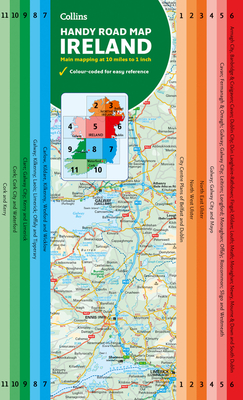
Back to topMap of Ireland Handy: Ideal for route planning (Collins Road Atlas) (Sheet map, folded)
$9.99
Backordered
Description
Explore new places with this authoritative map of Ireland.
Easy-to-use route-planning map covering the whole of Ireland opens almost like a book. It has the convenience of an atlas with all the benefits of a fold-out map, and features clear, full-color road maps at 10 miles to 1 inch plus city center plans of Belfast and Dublin.
The map is laminated on both sides making it very hard wearing and it comes in a plastic wallet.
Features include:
• Clear detailed mapping with attractive layer colors showing height
• Places of tourist interest and Tourist Information Centres shown
• Distance chart on the back of the map in both miles and kilometers
• Distances are shown on the roads to aid journey planning