You are here
Back to topMapping of Erosion Features Related to Thaw of Permafrost in the Noatak National Preserve, Alaska (Paperback)
Email or call for price
Description
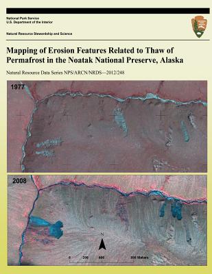
The newly acquired, nearly complete coverage of ARCN by high-resolution satellite imagery has allowed the NPS to make a comprehensive survey of erosion features caused by permafrost thaw in the Noatak National Preserve (NOAT). The author combined automated mapping methods with visual recognition of geomorphic features to make a comprehensive map of ALD and RTS in NOAT. The purpose of this report is to present the results of mapping in NOAT. Mapping in three other NPS units (Bering Land Bridge National Preserve (BELA), Cape Krusenstern National Monument (CAKR), and Kobuk Valley National Park (KOVA) was reported previously.